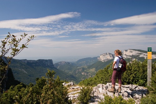
The Révoulat belvedere
La Chapelle-en-Vercors
The Révoulat belvedere
3h
8,3km
+443m
-440m
Embed this item to access it offline
For a large part in undergrowth, this hike offers you sumptuous panoramas, in particular between the lookout of Révoulat and the chemin des Falaises.
2 points of interest
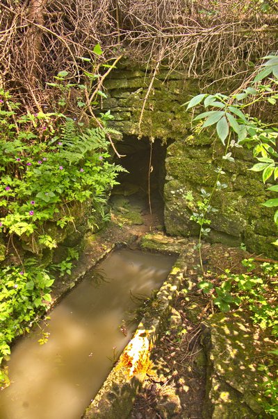
Le vieux bassin de l'Aigue - E. Charron The Aigue
Between the localities called Révoulat and l'Aigue, note, by the roadside, an ancient basin fed by a small spring covered with a vault. From the mountain of the Aigue, on your left, several sources sprang up which had allowed the installation of a hamlet in Révoulat.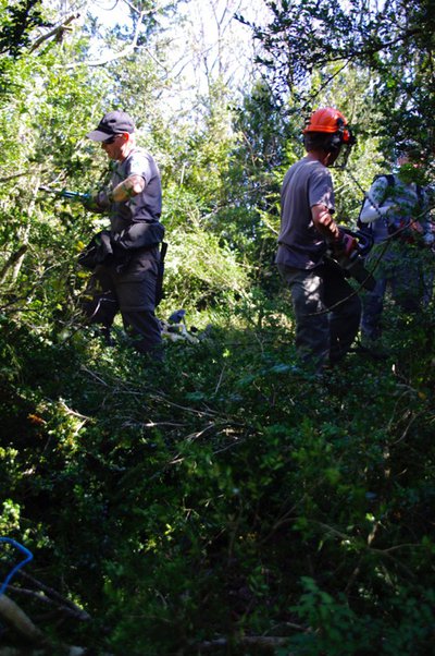
m_rocheblave The Chemin des Falaises
During a tour of maintenance and surveillance, an old path completely disappeared in the vegetation was rediscovered by the ecogardes of the Regional Natural Park of the Vercors. After consulting the cadastre, this trail turned out to be an old communal road. With the authorization of the commune of La Chapelle-en-Vercors and the technical support of local associations, the park's agents were able to re-open it and integrate it into the network of marked hiking trails. You will take it between the crossroads of the Rochers d'Echevis and the Chemin des cliffs. It offers in particular a beautiful viewpoint on the Gorge des Grands Goulets (watch out for the cliff). When you come to the direction sign Chemin des falaises, you will have to go up a little on your left, to find the crossroads of Rochas, and the continuation of the itinerary.
Description
Departure from La Croix Châtelard, direction Le Belvédère 4 by taking the track leading to the Grand Serre 1 then Révoulat 2 and L'Aigue 3, then continue on a nice path to reach Le Belvédère (Parents, attention to your children on the edge of the cliff!).
Return to La Croix de Châtelard via Les Rochers d'Echevis 5, Chemin des Falaises 6 Les Rochas 7 then Grand Cros 8 and the hamlet of Les Revoux.
From here, a last small ascent to the shrubbery of boxwood conditions the return to the starting point of this magnificent loop.
Return to La Croix de Châtelard via Les Rochers d'Echevis 5, Chemin des Falaises 6 Les Rochas 7 then Grand Cros 8 and the hamlet of Les Revoux.
From here, a last small ascent to the shrubbery of boxwood conditions the return to the starting point of this magnificent loop.
- Departure : Place name la Croix de Châtelard, La Chapelle-en-Vercors
- Arrival : Place name la Croix de Châtelard, La Chapelle-en-Vercors
- Towns crossed : La Chapelle-en-Vercors
Forecast
Altimetric profile
Sensitive areas
Along your trek, you will go through sensitive areas related to the presence of a specific species or environment. In these areas, an appropriate behaviour allows to contribute to their preservation. For detailed information, specific forms are accessible for each area.
Golden eagle
- Impacted practices:
- , ,
- Sensitivity periods:
- JanFebMarAprMayJunJulAug
- Contact:
Recommandations
Be careful with the approach of the edge of cliffs, parents watch your children well.
Use the passageways to cross the fences, close the gates and barriers, stay on the marked paths.
Stay on the marked paths is also respect private property.
Use the passageways to cross the fences, close the gates and barriers, stay on the marked paths.
Stay on the marked paths is also respect private property.
Information desks
Place Pietri, 26 420 La Chapelle-en-Vercors
Transport
By train :
Valence train stations
OùRA multimodal route planner : https://www.oura.com/
By bus :
From Valence :
From train and bus stations : Line D05 to Vassieux-en-Vercors
By hitch hiking : You can get there / get back by hitching a lift with the Rezo Pouce network from Autrans-Méaudre, Lans-en-Vercors, Grenoble and Royans-Vercors (you can find all the stops in the Vercors on www.rezopouce.fr).
Carpooling :
Offer your services or book your carpooling on the regional Mov'Ici platform.
Access and parking
From Vassieux-en-Vercors, take the D518 towards La Chapelle-en-Vercors. After the Chapelle-en-Vercors, take on your left the D256 in the direction of Loscence. Park in the parking lot at the Croix du Châtelard.
Parking :
Roadside on the Croix de Châtelard
Report a problem or an error
If you have found an error on this page or if you have noticed any problems during your hike, please report them to us here: