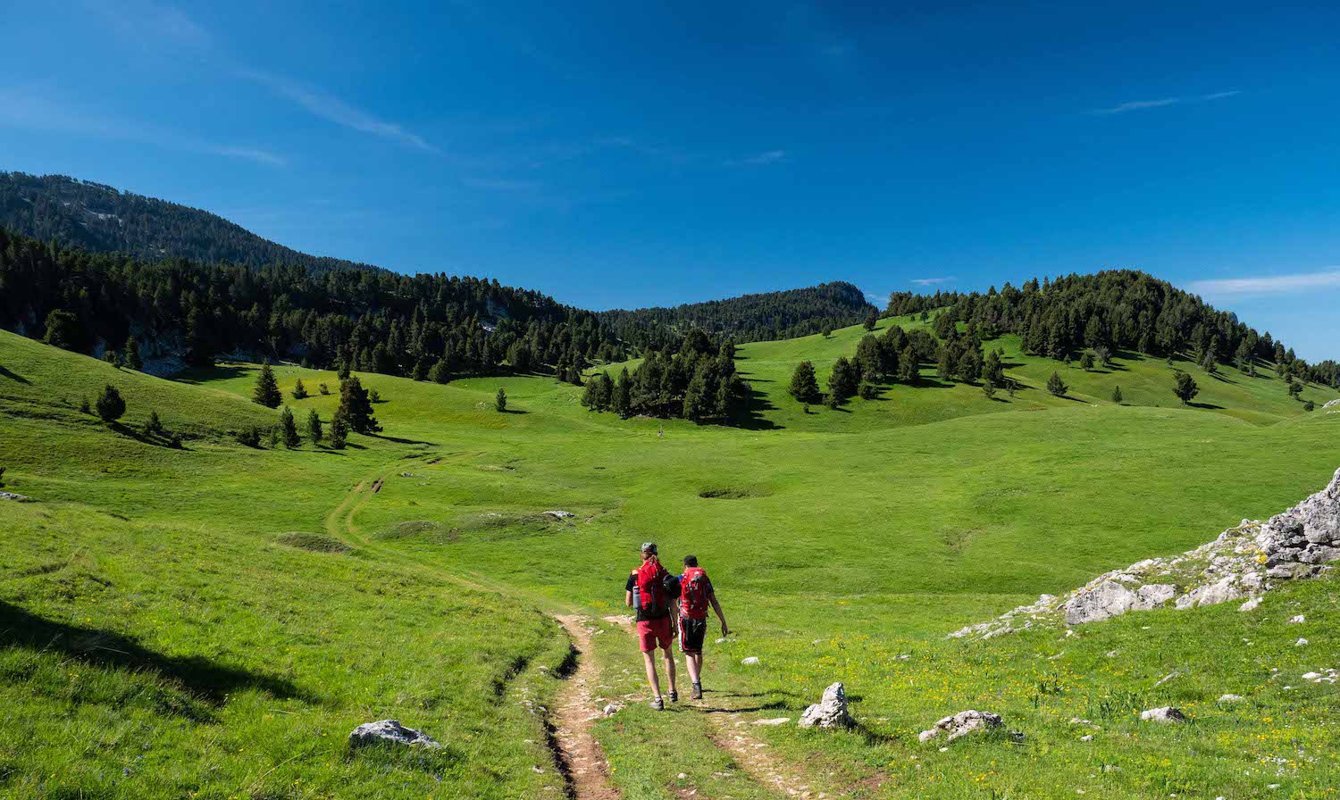
The Pison - Chabrinel pass
This hike begins by progressing in the large pine forests before reaching the Hauts-Plateaux du Vercors and its wide open spaces. From up there, the landscapes are even more grandiose.
6 points of interest
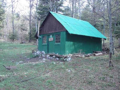
Abri du Pison Shelter of the Pison
A short distance from the Hauts-plateaux at 1540 m, the shelter of the Pison is a shack in sheet metal, able to accomodate 6 people. It has a stove.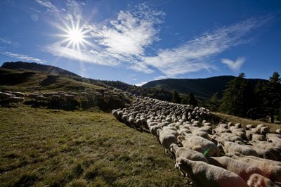
S.M Booth Col du Pison
The Col de Pison gives access to the Glandasse mountain, which overlooks the Diois from its 2041 m high. Its cliffs are appreciated for climbing, while its summit plateau is a place of estive for many sheep. Included in the nature reserve of the Hauts Plateaux of the Vercors, the fauna and flora are rich.
Réserve Naturelle - S.M Booth The Nature reserve of the Hauts-Plateaux of Vercors
Unique by its size of 17,000 hectares, the Réserve des Hauts-Plateaux extends over 10% of the territory of the Regional Natural Park of Vercors. Today it is the largest terrestrial reserve in metropolitan France. Between 1050 m and 2341 m of altitude (with the Grand Veymont in climax), it undergoes very contrasted climatic influences, at the hinge between the northern and southern pre-Alps. The strong seasonal human presence has shaped it since prehistoric times. Pastoralism has been practiced there for over a thousand years.Now marked by an alternation of mountain pastures and forests, the Reserve has the largest forest of hooked pines in the limestone Alps and a rich flora of 738 species. Animal life is discreet but abundant.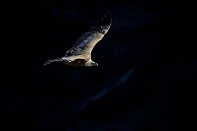
vautour - S&M Booth The Vulture Ball
At the dawn of the 2000s, the Regional Natural Park of Vercors participated in an operation to reintroduce vultures fawn on the scale of the Pre-Alps. These birds had disappeared from our mountains in the 19th century. By relying on the population of the Grands Causses, the idea was to exchange (birds, and therefore genes) with the Pyrenean populations. A vast population occupies a space that goes from the Spanish Pyrenees to the Vercors, which the birds traverse freely (the observation of the banded birds proves it to us). The Col de Rousset and the circus of Archiane are two sites of rest and nesting for these great gliders (almost 3m of wingspan). They use the ascending currents along the cliffs to transit from one to the other. A large shadow on the ground, raise your head, a vulture passes over you ...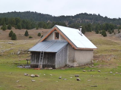
Pré Peyret - PNRV At the crossroads of several important trails, the Cabin de Pre Peyret is one of the most frequented of the massif. Located at the entrance of the high plateaus at 1600 m, this unguarded stone hut can accommodate 10 people for the night. It has a stove.The place exudes an old tradition of welcome because it is an old cabaret where those who were penniless went to drink at the Fountain of the Endettés, which bears his name well.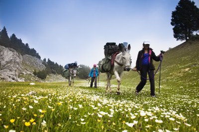
Pas de Chabrinel - S.M Booth The Pas de Chabrinel
The Pas de Chabrinel is one of the gateways to the Plateau du Vercors. During the descent stands facing you the Dent de Die, as laid down on the side of Mountain. From the height of 1610 m, it dominates the Diois.
Description
1.">Departure from Fournaire (parking), take the forest road to join Les Drayes 1. 2, atteindre par un joli sentier en forêt le Pas de Pillouse 3, poursuivre jusqu'au Col de Vire Sac.">Then take the direction of the Col de Vire Sac 2, reach by a nice path in the forest the Pas de Pillouse 3, continue until Col de Vire Sac. 4.">From there, follow the itinerary that goes towards the North, to pass near the characteristic rock of the Dent de Die, before arriving at the crossroads of Lentillière 4. 5, pour déboucher un peu plus haut à Pison 6 sur le plateau (attention vous pénétrez dès lors dans la Réserve naturelle des">Continue on the trail in the balcony (always yellow-green markings), passage to the shelter of the Pison 5, to unbuckle a little higher to Pison 6 on the plateau (attention you penetrate then in the Natural reserve of the High plateaux of the Vercors, with a specific regulation to know and respect!). 7.">Now take the route of GR 91 and 93 (white-red markings), running north to Pré Peyret 7. At Pré Peyret, take the GR 93 direction of the Col du Rousset until the Pré Peyret shelter. From here, take the path leading to the Pas de Chabrinel to the south, before gradually starting the descent, towards Romeyer (pay attention to certain passages in the scree, especially in rainy weather). 8, Serre Reynier 9 et Les Echaliers 10 , un chemin puis une piste forestière permet de terminer cette grande randonnée par Le Château">Follow the yellow-green markup to the parking of Fournaire, passing at the crossroads Les Gravelles 8, Serre Reynier 9 and Les Echaliers 10, a path then a forest trail allows to finish this great hike by Le Château 11 et Les Drayes.">11 and Les Drayes.
- Departure : Place name Fournaire, north of Romeyer
- Arrival : Place name Fournaire, north of Romeyer
- Towns crossed : Romeyer, Chichilianne, and Gresse-en-Vercors
Forecast
Altimetric profile
Sensitive areas
- Impacted practices:
- , ,
- Sensitivity periods:
- JanFebMarAprMayJunJulAugSep
- Contact:
- https://www.parc-du-vercors.fr/
Griffon vulture
- Impacted practices:
- , ,
- Sensitivity periods:
- JanFebMarAprMayJunJulAugDec
- Contact:
- nicolas.renous@pnr-vercors.fr
Recommandations
You will enter the Hautes-Plateaux Nature Reserve of the Vercors, with a specific regulation to know and respect!

Beware in rainy weather, some technical passages can be delicate and slippery!
Use the passageways to cross the fences, close the gates and barriers.
Stay on the marked paths is also respect private property.
You are at certain times of the year on summery areas, maybe you will meet protective dogs, often Patous. Always be sure to bypass the herds, while remaining calm while the dog identifies you, not caressing or threatening them. If you have a dog, keep it on a leash.
Information desks
Transport
By train : Die train station
Carpooling :
Offer your services or book your carpooling on the regional Mov'Ici platform.
Access and parking
From Die, take the D742 towards Romeyer, cross the village and climb up to Fournaire (parking).
Parking :
Report a problem or an error
If you have found an error on this page or if you have noticed any problems during your hike, please report them to us here: