The Nan gorges
Cognin-les-Gorges


The Nan gorges
5h
14km
+1070m
-1070m
Embed this item to access it offline
Join the magnificent Gorges du Nan (site classified Espace Naturel Sensible) and their freshness, before discovering the village of Malleval-en-Vercors, a place of resistance during the Second World War. The return takes place mainly in undergrowth, in the middle of beech, oak and boxwood.
2 points of interest
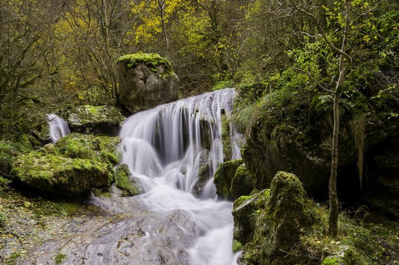
Gorges du Nan - m_rocheblave The Gorges du Nan
The Gorges du Nan, a remarkable site that recently earned them to be classified as a Sensitive Natural Area. Indeed, these gorges shaped by the Nan, are dominated by impressive cliffs, where one can study the geological history of the Vercors, thanks to the different geological strata, vestiges of sedimentary deposits for thousands of years. The natural heritage is also rich, both for its flora, including the elegant doradilla (small fern) or the juniper thurifera, as for its fauna, with the presence of the peregrine falcon.
The inclined slab
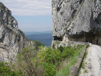
At about ten meters on the right of the trail, you can observe a geological curiosity with this inclined slab.The men had set up a shelter under rock quite original!
Description
Departure from Cognin-les-Gorges parking place of the village, take the direction of Malleval. The walk begins by passing the Pont de Montchardon 1, then continues to the bottom of the Gorges du Nan along the creek of the same name (yellow-green markings). Arriving at the crossroads Gorges du Nan 2, rally La Croix de Gene 4 passing by Le Moulin 3. Continue to La Fontaine 5 (hostel Galopins to 200 meters). From then on, you will follow the yellow-red markings of the Tour des Coulmes passing by Croix de Railletière 6, Chez Courtieu 7, La Vieille 8 and Le Fayard de Gontier 9. From there, start the return and the descent on Cognin-les-Gorges (again yellow-green markings) joining Freissinet 10 then Bassin d'Inard 11. The path leads you to Pont de Montchardon and then to the village.
- Departure : Cognin-les-Gorges (parking place of the village)
- Arrival : Cognin-les-Gorges (parking place of the village)
- Towns crossed : Cognin-les-Gorges, Malleval-en-Vercors, and Izeron
Forecast
Altimetric profile
Sensitive areas
Along your trek, you will go through sensitive areas related to the presence of a specific species or environment. In these areas, an appropriate behaviour allows to contribute to their preservation. For detailed information, specific forms are accessible for each area.
Golden eagle
- Impacted practices:
- , ,
- Sensitivity periods:
- JanFebMarAprMayJunJulAug
- Contact:
Golden eagle
- Impacted practices:
- , ,
- Sensitivity periods:
- JanFebMarAprMayJunJulAug
- Contact:
Recommandations
Caution in rainy weather, some passages can be delicate and slippery!
Information desks
48 Grande Rue, 38680 Pont-en-Royans
Transport
By Bus :
From Valence take the regional bus service, line T60 (Grenoble - Pont-en-Royans, stop at Cognin-les-Gorges)
By hitch hiking :
Discover Rezo Pouce service with all the official stops on https://www.rezopouce.fr
Carpooling :
Offer your services or book your carpooling on the regional Mov'Ici platform.
Access and parking
From Romans-sur-Isère, take the A49 towards Grenoble, then take exit number 10 to Cognin-les-Gorges. Follow the D1532 until the village, parking on the village square.
From Grenoble take the A48 then the A49 towards Valence, take the exit n ° 10 in the direction of Cognin-les-Gorges. Then follow the D1532 to the village, parking on the village square.
From Grenoble take the A48 then the A49 towards Valence, take the exit n ° 10 in the direction of Cognin-les-Gorges. Then follow the D1532 to the village, parking on the village square.
Parking :
Parking in the Rue de la Vieille Église
Report a problem or an error
If you have found an error on this page or if you have noticed any problems during your hike, please report them to us here: