
Walk via the Haut-Plateaux du Vercors : Corrençon / Jasse du Play (stage 1)
In the vastness of the Hauts Plateaux, there is a profound sense of solitude, with only a few scattered huts and shelters along the route. There is nowhere for replenishing supplies, and mobile phone coverage is highly unreliable. This is one of France's last untouched wildernesses, perfect for adventurers.
6 points of interest
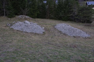
Murgers (PNRV) - PNRV Les Murgers
The name would come from a Burgundian word. It is true that from Bourgogne to the Ardèche, the stones grow well in limestone fields! These piles of pebbles at the edge of the field are the result of the stoning patient, over time, realized by generations of obstinate peasants to gain arable land. Sometimes, they are mounted in low walls to delimit enclosures and plots.It is also a beautiful refuge for rampant wildlife in search of shelter.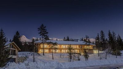
Zecamp Zecamp
A few months ago, Marie Dorin-Habert, accompanied by her husband, Lois, and the cross-country skier, Robin Duvillard, set themselves an innovative and interesting project, called "Zecamp". Zecamp is an accommodation and restaurant structure at the departure point for the cross-country skiing, golf and Vercors high plateau reserve trails, open to the general public all year round. Created by high level sports people living in the Vercors, the formula is more suited to a sporty public, with healthy food, the provision of maps and GPS indications, a weight room, equipment storage and repair rooms and offers for Vercors activities. The "Zecamp Outdoor Activity Center" should open in Autumn 2018 in Corrençon-en-Vercors. see the video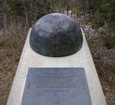
Monument du 45ème Parallèle (PNRV) - PNRV 45th Parallel
The 45th parallel of north latitude is halfway between Ecuador and the North Pole, which are each 5,000 kilometers away. At the same latitude, there is the Danube Delta Biosphere Reserve in Europe, and in Yellowstone National Park, created in 1872 and the first national park in the world.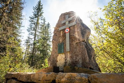
Stèle du Camp 2 - Focus outdoor The CAMP 2 of the maquis of Vercors
It was at the Puits des Ravières that the CAMP 2 of the maquis of Vercors was installed in 1942; Bringing together young people who refrains from the occupation of France. Indeed, here water is rare, it is one of the rare places where shepherds, hunters, woodcutters, speleos and maquisards have drawn water.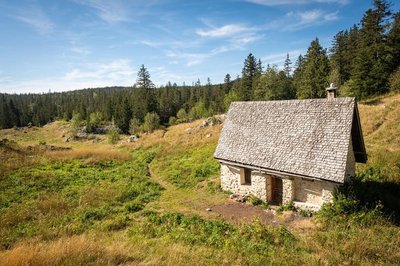
Cabane de Carette - Focus outdoor Cabane of Carrette
The carette hut is an old sheepfold restored by the Parc du Vercors and transformed into an unguarded refuge. This beautiful hut indicates the entrance to the Natural Reserve of Hauts-Plateaux du Vercors.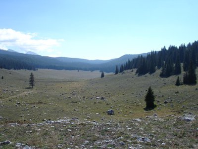
Darbounouse - PNRV Prairie of Darbounouse
The prairie of Darbounouse is a so-called cold combe. The accumulation of a semi-continental climate and altitude is aggravated by the nocturnal inversion of temperature (the denser cold air is lodged in the hollows). The weather station installed in the framework of the Vercors eco-climatic observatory recorded a record negative temperature with -38 ° C in 2000.
Description
→ Corrençon-en-Vercors / 1 Le Golf
(+ 38 m / - 4 m / 1,3 km / 20 mn)
Le Golf / 2 Le Clariant
(+ 82 m / 1,8 km / 35 mn)
Le Clariant / 3 The 45th Parallel
(+ 60 m / - 10 m / 1,5 km / 30 mn)
The 45th Parallel / 4 Carette hut
(+ 91 m / - 4 m / 1,9 km / 35 mn)
Carette hut / 5 Darbounouse
(+ 79 m / - 113 m / 3 km / 45 mn)
Darbounouse / 6 Clapes de Cognaux
(+ 431 m / - 169 m / 8,4 km / 2h 30)
Clapes de Cognaux / Jasse du Play (shelter)
(+ 33 m / - 3 m / 0,8 km / 15 mn)
After the Darbounouse sheepfold, the trail continues southwards, mainly through forested areas. Directional signs are few and far between in the Hauts Plateaux Nature Reserve, and you must be sure to follow the GR 91 white and red markers carefully. This commitment to leaving the land untouched means that hikers can explore a natural landscape that is wild and unspoiled. Although it is not difficult to find your bearings when the weather is good, be careful not to stray from the signposted trail in fog.
Navigating in bad weather requires a compass and/or GPS together with a 1:25,000 scale map.
- Departure : Corrençon-en-Vercors (village)
- Arrival : Jasse du Play shelter
- Towns crossed : Corrençon-en-Vercors, Gresse-en-Vercors, Saint-Agnan-en-Vercors, and Saint-Andéol
Forecast
Sensitive areas
- Impacted practices:
- , ,
- Sensitivity periods:
- JanFebMarAprMayJunJulAugSep
- Contact:
- https://www.parc-du-vercors.fr/
Recommandations
Please note: you are in the Hauts Plateaux du Vercors Nature Reserve, where there are specific regulations that you need to know and follow!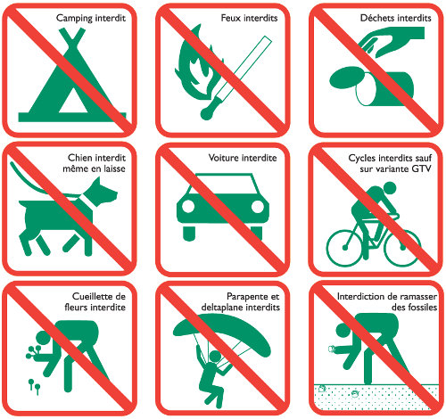
The route is straightforward when the weather is clear. But bad weather can make orientation tricky, and there is no mobile phone reception.
In summer, one of the main difficulties is managing your supply of water. For more information on the flow rate of the springs, please consult infosource website before you start your journey.
If you are not very experienced, don’t think twice about calling on the services of a trained, skilled mountain guide.
Information desks
101 place Mure-Ravaud, 38250 Villard-de-Lans
Place Pietri, 26 420 La Chapelle-en-Vercors
Transport
By train : Grenoble train station
The OùRA multimodal route planner provides information about all the connections between regional trains, urban transport and departmental bus lines: https://www.oura.com/
By bus : From Grenoble, take the regional shuttles T65 or T64 coaches for Lans-en-Vercors and then line T64 to Corrençon.
By hitch hiking : You can get there / get back by hitching a lift with the Rezo Pouce network from Autrans-Méaudre, Lans-en-Vercors, Grenoble and Royans-Vercors (you can find all the stops in the Vercors on www.rezopouce.fr).
Carpooling :
Offer your services or book your carpooling on the regional Mov'Ici platform.
Access and parking
From Grenoble, take the direction to Sassenage then the road D531 going to Villard-de-Lans.
Keep driving on the D531 to Corrençon-en-Vercors.
From Valence, take the direction to Grenoble then Pont-en-Royans, Villard-de-Lans and at least go to Corrençon-en-Vercors.
Parking :
More information
Report a problem or an error
If you have found an error on this page or if you have noticed any problems during your hike, please report them to us here: