
My trail circuit by: Marie Dorin-Habert
2 points of interest
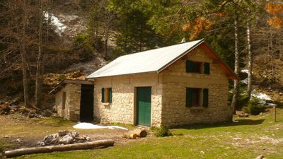
Abri de la Fauge - PNRV Shelter of the Fauge
The Fauge Shelter is a large, unguarded hut. With a fireplace, it can accommodate 20 people. It is named after the valley of the Fauge.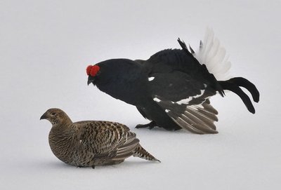
Tétras-Lyre Vercors - PNRV Tétras Lyre (Black Grouse)
This crossroads takes its name from the black grouse. This sedentary bird is one of the symbols of the Vercors Regional Nature Park. It appears on the park's logo, in the company of the wild tulip. During the breeding season (April-May) the cock sings at daybreak. But do not try to see it and above all stay on the roads, because this remarkable species is very sensitive to disturbance.
Description
The track leading to the Pas de l'Oeille 2 seems like it will never end. Having passed the Combe Charbonnière scree 1 - and been spotted by a marmot with its strident whistle - a beautiful panoramic crossing awaits you.
The climb continues in a cunning way - the top seems to move farther away and each new outcrop leads to another one as you stroll amongst the limestone rocks. Be careful not to twist your ankle!!
And then the stones give way to a grassy valley and you find yourself close to the Pas de l'Oeille. A herd of ibex often grazes peacefully, sheltered from the wind under the summit. It is a magnificent place.
Take a souvenir photo when you arrive at the Pas de l'Oeille!
And then you disappear down the other side, on the eastern slope by a really steep and not very pleasant descent, but which doesn't last too long.
The path levels out and you can admire the countryside that takes us to the next gateway: the Pas de la Balme. The first time, you are a bit worried that you will miss the path and head towards Chichilianne... But don't panic, the intersection is well indicated and it takes a while to arrive (30 min for very good runners, 1hr 30 for a good walker).
Once you are on the path, it climbs with increasingly close zigzags, finishing under the cliff, sometimes accompanied by a couple of ibex. You then reach the Pas de la Balme 3.
You can then easily cross towards the top of the alpine ski runs.
The descent towards the village of Corrençon is less interesting. You can go straight down via the ski runs and get your quadriceps steaming, which is a useful workout for this eccentric muscle chain. Otherwise, a small trail follows the ski runs on the left (don't worry, your thighs will also get a workout this way!).
My choice is to go to the Golf de Corrençon 4, the shooting range and...
As an assisted athlete, my rifle, coach, shooting mat, cartridges... are all waiting for me for a precision session!
- Departure : Les Clots car park (Villard-de-Lans)
- Arrival : Corrençon Golf Course (car park)
- Towns crossed : Château-Bernard, Corrençon-en-Vercors, Le Gua, and Villard-de-Lans
Forecast
Sensitive areas
Black grouse - winter
- Impacted practices:
- , , ,
- Sensitivity periods:
- JanFebMarAprDec
- Contact:
- Fédération Départementale des Chasseurs d'Isère :
Yannick Buzzarello
yannick.buzzarello@chasse38.com
Membre de l'Observatoire des Galliformes de montagne :
Virginie Dos Santos
ogm.vds@gmail.com
Blandine Amblard
ogm.amblard@gmail.com
Recommandations
The Champions Trails are specific training trails (difficult and technical) which do not always correspond to the signalled itineraries on the ground. The technical descriptions are not as precise as those for the other Vercors Rando circuits. Usual practice is to download the gpx trace in order to follow the itinerary.
Be careful in rain and fog as certain passages may be slippery and technical (particularly the Pas de l'Oeille crossing).
For obvious safety reasons, this itinerary can ONLY be followed in its entirety outside of the snow period!
Take advice about snow cover (sometimes late) at the start of the season.
You will cross summer pastures, and maybe meet herd protection and guard dogs.
Always ensure that you go a long way around the animals, calmly so that the dog can identify you. Don't caress or threaten them.
Keep dogs on leads!
Information desks
101 place Mure-Ravaud, 38250 Villard-de-Lans
Transport
The OùRA multimodal route planner provides information about all the connections between regional trains, urban transport and departmental bus lines : https://www.oura.com/
By bus : With regional coaches T65 or T64 from Grenoble to Corrençon-en-Vercors.
By hitch hiking : You can get there / get back by hitching a lift with the Rezo Pouce network from Autrans-Méaudre, Lans-en-Vercors, Grenoble and Royans-Vercors (you can find all the stops in the Vercors on www.rezopouce.fr).
Carpooling :
Offer your services or book your carpooling on the regional Mov'Ici platform.
More information
Report a problem or an error
If you have found an error on this page or if you have noticed any problems during your hike, please report them to us here: