The Bruyères
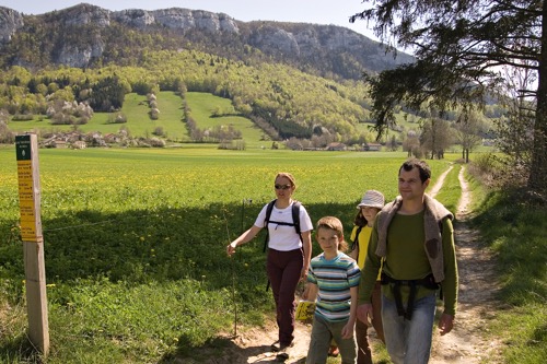
La Chapelle-en-Vercors


The Bruyères
1h30
4,9km
+141m
-143m
Embed this item to access it offline
Discover the traces of the history of Chapelle-en-Vercors, whose village was largely destroyed during the Second World War.
3 points of interest
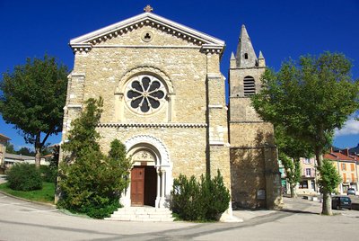
L'église de La Chapelle-en-Vercors - E. Charron The reconstruction of the village
The start of the hike takes you past the church. Its bell-tower (listed) of the twelfth century is one of the rare buildings that escaped the bombing and the fire of the village in July 1944. If the houses all have a similar architecture, it is because they were completely rebuilt from 1948 onwards. It is in temporary buildings (some of which are still visible at the exit of the village towards Vassieux) that the inhabitants lived for six years for some, in particular the very cold winters 1946 and 47.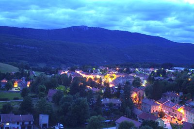
La Chapelle-en-Vercors à la tombée de la nuit, vue des ruines de Foirevielle - E. Charron The castle Foirevielle
A small detour through the ruins (very discreet) of the castle of Foirevielle offers a beautiful view on La Chapelle-en-Vercors and the surrounding valleys. In the ninth century, this caste motte watched the roads coming from Vassieux or the col de Rousset. The village of Bâtie de l'Orme and then of the Bâtie de Vercors huddled at his feet. It was in the twelfth century that the villagers moved the village to the present location.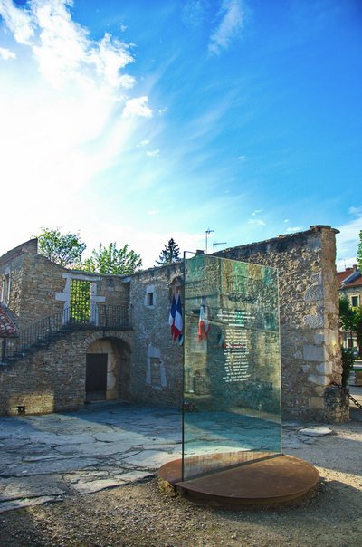
La cour des fusillés et son mémorial - E. Charron The courtyard of the farm Albert
Back in the village, next to the post office, the ruins of the farm Albert are also called "Cour des fusillés". On 25 July 1945, while the non-escaped inhabitants were held hostage in the school and the Wafen SS troops burned down the village, 16 young men and the schoolmaster were shot this location. To the right of the remains of the surrounding wall, a small memorial recalls these events.
Description
- Departure from La Chapelle-en-Vercors (in front of the Tourist Office), go before the town hall before turning left, then right on the right the road that allows to join Les Bruyères
- From there, continue on the road about 200 meters before turning on the right in the direction of the crossroads Le Lauzet
- From Lauzet, follow Les Chaberts then Les Chaux and turn right to reach Le Château. A little further on at the crossroads Sous Le Château, you have the possibility to return at the start of the walk directly (direction La Chapelle-en-Vercors), or to go to the ruins of Château de Foirevieille then return to the center of the village.
- Departure : La Chapelle-en-Vercors (village)
- Arrival : La Chapelle-en-Vercors (village)
- Towns crossed : La Chapelle-en-Vercors
Forecast
Recommandations
Use the passageways to cross the fences, close the gates and barriers, stay on the marked paths.
Stay on the marked paths is also respect private property.
Stay on the marked paths is also respect private property.
Information desks
Place Pietri, 26 420 La Chapelle-en-Vercors
Transport
By bus :
From Valence :
From train and bus stations : Line D05 to Vassieux-en-Vercors
By hitch hiking : You can get there / get back by hitching a lift with the Rezo Pouce network from Autrans-Méaudre, Lans-en-Vercors, Grenoble and Royans-Vercors (you can find all the stops in the Vercors on www.rezopouce.fr).
Carpooling :
Offer your services or book your carpooling on the regional Mov'Ici platform.
Access and parking
From the Col de Rousset, follow the D518 towards La Chapelle-en-Vercors.
From Villard-de-Lans, follow the D531 then the D103 via Saint-Julien-en-Vercors and Saint-Martin-en-Vercors, before following the D518 La Chapelle-en-Vercors.
From Villard-de-Lans, follow the D531 then the D103 via Saint-Julien-en-Vercors and Saint-Martin-en-Vercors, before following the D518 La Chapelle-en-Vercors.
Parking :
Parking in the village
Report a problem or an error
If you have found an error on this page or if you have noticed any problems during your hike, please report them to us here: