Côte Chèvre pass - Rock of Combau
Treschenu-Creyers


Côte Chèvre pass - Rock of Combau
4h30
10,5km
+754m
-754m
Embed this item to access it offline
The view on the southern part of the Vercors nature reserve (Glandasse, Archiane), the charm of the valley of Combau and the memory of an old still, so many curiosities to discover on this beautiful hike with particular atmospheres.
3 points of interest
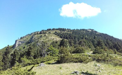
Le col de Côte Chèvre - M. Morin Col de Côte Chèvre
From the Cote de Chèvre pass, admire the panorama on the southern part of the Hauts-Plateaux du Vercors nature reserve, but also on the Serre de Beaupuy.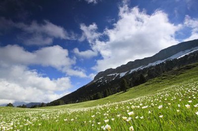
Renoncules à Combau - S&M Booth Vallon of Combau
Dominated by the Montagnette (1972 m), the sumptuous valley of Combau is a valley in trough (its bottom is flat and its slopes stiff). In the spring, the flora covers the valley: you can admire daffodils, orchids including the hoof of Venus, pines with hooks and a multitude of other species characteristic of mountain flora. In the summer, the valley is a place of grazing for the sheep, which maintain this open space.Attention: Flower picking is regulated.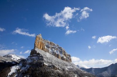
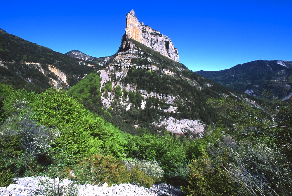
Rocher de Combeau en hiver - S&M Booth Rock of Combau
From its height of 1593 m, the Rock of Combau majestically dominates the valley that bears its name. This rocky limestone spur is the fruit of thousands of years of erosion.
Description
Departure of Nonières (parking in the hamlet), direction Col de Côte Chèvre 1. Follow the yellow-green markings and take the path just behind the hotel "Le Mont Barral". Farther on, cut the road to Col de Menée and continue between forests and clearings. The trail follows a wood of spruces and pines with hooks to emerge at the Col de Côte Chèvre. After enjoying the spectacular view, this hike continues through the crossing of a scree before reaching the road at the crossroads Granges de Combau 2. For a moment, take the road that goes around the rock of Combau, to the directional post that tells you Liodève 3. From there, leave the tar for a nice path in the underbrush that runs along the creek of Combau (always yellow and green markings). After crossing the road again twice, reach Liodève. The return to Nonières is effected by the GR 93.
- Departure : Les Nonières, Treschenu-Creyers
- Arrival : Les Nonières, Treschenu-Creyers
- Towns crossed : Treschenu-Creyers
Forecast
Altimetric profile
Sensitive areas
Along your trek, you will go through sensitive areas related to the presence of a specific species or environment. In these areas, an appropriate behaviour allows to contribute to their preservation. For detailed information, specific forms are accessible for each area.
Golden eagle
- Impacted practices:
- , ,
- Sensitivity periods:
- JanFebMarAprMayJunJulAug
- Contact:
- nicolas.renous@pnr-vercors.fr
Recommandations
Use the passageways to cross the fences, close the gates and barriers, stay on the marked paths.
Stay on the marked paths is also respect private property.
Stay on the marked paths is also respect private property.
Information desks
Square Jean Giono, 26410 Châtillon-en-Diois
Transport
By train :
Die Train station
The OùRA multimodal route planner provides information about all the connections between regional trains, urban transport and departmental bus lines: https://www.oura.com/
By Bus :
From Valence or Crest, take the regional bus service, line D29, then reach the start by carpooling or hitchhike.
Carpooling :
Offer your services or book your carpooling on the regional Mov'Ici platform.
Access and parking
From Châtillon-en-Diois, take the direction of Menée by the D120, until the hamlet Les Nonières.
From Chichilianne, take the D7 until Col de Menée then the D120 in the direction of Châtillon-en-Diois, until the hamlet of Nonières.
From Chichilianne, take the D7 until Col de Menée then the D120 in the direction of Châtillon-en-Diois, until the hamlet of Nonières.
Parking :
Parking in the hamlet of Nonières
Report a problem or an error
If you have found an error on this page or if you have noticed any problems during your hike, please report them to us here: