Mont Aiguille circuit
Chichilianne

Mont Aiguille circuit
6h
17,5km
+1116m
-1102m
Embed this item to access it offline
With Mont Aiguille constantly in sight, this hike showcases the architectural wealth and curiosities of Trièves, including the Trézanne chapel. Woodland alternates with meadows and picturesque hamlets.
5 points of interest
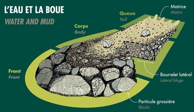
Torrent des Ruines
The toponym “les Ruines” is common in the Alps, often referring to unstable terrain that suffers heavy erosion and torrential flooding: lava, a mixture of water, earth and blocks of stone. The floods move at speed (at tens of km/h) in a very straight, steep channel, but behave like a drift that can transport blocks several cubic meters in size (the equivalent of a car or even a van) just like volcanic lava.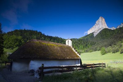
Chapelle de Trézanne - S&M Booth Chapel of Trézanne
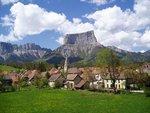
Nestled at the foot of Mount Aiguille, the Chapel of Trézanne offers a magnificent view of this majestic mountain, overlooking it more than 1000 m. This small Romanesque chapel is characterized by its thatched roof which was rehabilitated in 2001 and recently renovated. Before the eighteenth century, the thatched roofs were numerous in the Trièves: they were gradually replaced by tile roofing, notably because of the fires.
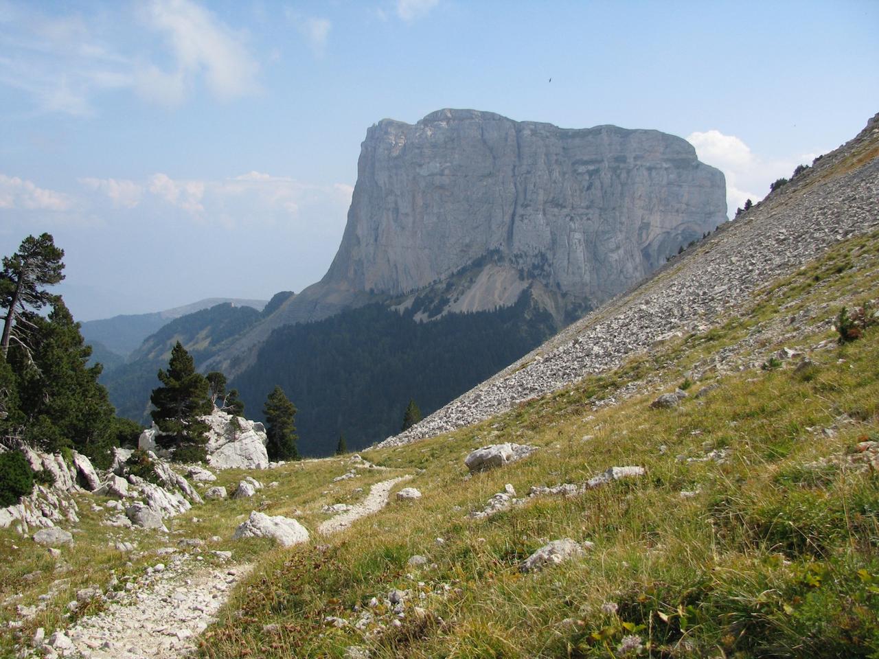
Mont Aiguille - S&M Booth Mont Aiguille
The Mont Aiguille, from its 2087 meters, is a mound of the eastern barrier of the Vercors. Indeed, the Mount is composed of the same materials as the rest of the plateau (limestones and marls deposited by the sea before the rising of the Alps) to which it was formerly attached. The most tender limestones and the presence of numerous faults facilitated the dissolution of the limestone over time, leading to the isolation of Mount.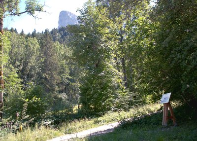
B. Brun-Cosme Font Rousse camp
Shacks were built here to house young men as part of the paramilitary youth workcamps – Chantiers de Jeunesse – belonging to the Monestier-de-Clermont group, which were set up during the summer of 1940. The task was to instil a sense of discipline and duty together with respect for authority, since military service was no longer permitted under the conditions imposed by the Armistice (June 22, 1940). Working in the forest kept the young men busy, while festivals were held to glorify the commitment to the homeland. The group's workcamps closed in early October 1943. A short while later, members of the Resistance from Camp 2 (initially set up at Puit des Ravières in Corrençon) dropped down through the highland areas of the Vercors to the sheepfold near the sawmill before moving on to the premises deserted by the Chantiers de Jeunesse. Louis Kalck (André) took over command of the Font Rousse camp before handing it over to Jean Beschet in the spring. The latter orchestrated the ambush against the German convoy that was crossing the Allimas pass on July 3, 1944.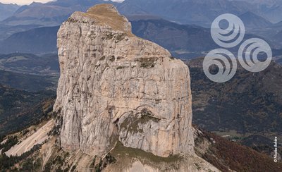
The Mont Aiguille, object of fantasy
This grassy patch of barely 5 ha is an island of vegetation separated from the rest of the Vercors massif. In Medieval times, it evoked the idea of an earthly paradise, which God made inaccessible to humans because of original sin.
The first ascent in 1492 made it possible to discover a beautiful garden, populated with chamois and birds, dotted with flowers, including the white lily, heraldic symbol of French royalty. This was taken to mean that this pristine space had always been promised to the King. Three crosses were erected, visible from below, to show that this plot of land was attached to the kingdom of France and the Christian world.
Description
- From Richardière hamlet (carpark), head for Chichilianne up to Pont de Donnière bridge. From there, go to the Fontaines intersection and join the Grand Tour du Vercors on foot circuit to reach Trézanne hamlet, via Les Ruines. From Trézanne and its beautiful thatched-roof chapel, keep walking north wards Col de Papavet pass. Go through Seiterat then Les Brutinels and Les Sagnes.
- From Papayet pass, enjoy the breathtaking panorama of Mont Aiguille and then head for Col des Pellas pass. Head gradually to the Chez Cotte intersection via Les Grands Clots, Caraby and Les Pellas. Leave the Grand Tour du Vercors circuit which heads off to Gresse-en-Vercors, and instead turn left on the road then the trail heading for Les Granges.
- Walk up to Col de l'Aupet pass via the place known as Sous la Cascade de la Pisse (under the Pisse waterfall). From this pass, you can feel so near to and yet so far from Mont Aiguille, and enjoy a beautiful view of the southern slope. Begin the descent via a pleasant path that winds through the forest to Richardière.
- Departure : Richardière hamlet (carpark), Chichilianne
- Arrival : Richardière hamlet (carpark), Chichilianne
- Towns crossed : Chichilianne, Saint-Martin-de-Clelles, Saint-Michel-les-Portes, and Gresse-en-Vercors
Forecast
Altimetric profile
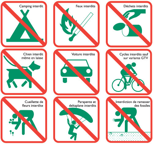
Sensitive areas
Along your trek, you will go through sensitive areas related to the presence of a specific species or environment. In these areas, an appropriate behaviour allows to contribute to their preservation. For detailed information, specific forms are accessible for each area.
Large plateaus at an average altitude of 1,600m, these landscapes are well-known to lovers of wide open spaces where humans have discreetly left their mark over the centuries. The fauna and flora also appreciate these places, where you can observe the two emblems of the Park: the wild tulip and the black grouse. Rock birds particularly appreciate the large cliffs that border these plateaus, and mountain orchids brighten the sparse mountain pine forest. Classified as a National Nature Reserve since 1985, this heart of nature benefits from strong protection. Human activities are regulated, and certain rules apply to everyone: dogs are prohibited, even on a leash; fires are also prohibited, as are motor vehicles, except for professionals (shepherds and breeders, forest managers, and rangers); bivouacking is possible, but tents must be taken down every day. Overflight is prohibited below 300m
- Impacted practices:
- , ,
- Sensitivity periods:
- JanFebMarAprMayJunJulAugSep
- Contact:
- https://www.parc-du-vercors.fr/
Recommandations
Please note you are going to cross several times the limits of the Nature Reserve of the Vercors Hauts-Plateaux, which have specific rules you need to know and respect.
Be careful, when it’s raining, some of technical sections can be tricky and slippery.
Please use the purpose-built gates and stiles to cross fences; shut gates and fasten behind you.
Keeping to the signposted paths means you'll respect private property.
Be careful, when it’s raining, some of technical sections can be tricky and slippery.
Please use the purpose-built gates and stiles to cross fences; shut gates and fasten behind you.
Keeping to the signposted paths means you'll respect private property.
Information desks
Le Village, 38930 Chichilianne
Transport
By Train :
Train station Clelles-Mens
The OùRA multimodal route planner provides information about all the connections between regional trains, urban transport and departmental bus lines: https://www.oura.com/
By Bus :
Scholar coaches line MEN05 (only on weekdays) and descend at Chichilianne. Reach the hiking start walking or by hitchhike.
Carpooling :
Offer your services or book your carpooling on the regional Mov'Ici platform.
Access and parking
From Monestier-de-Clermont, take the D1075 road, to Clelles, then follow the signs to Chichilianne via the D7 road, before taking the D7B road to Richardière hamlet.
Report a problem or an error
If you have found an error on this page or if you have noticed any problems during your hike, please report them to us here: