

2. Walk via the Haut-Plateaux du Vercors : Jasse du Play / Pré Peyret (stage 2 - GTV - GR®91)


Description
(+ 87 m / - 88 m / 3,7 km / 1 h)
→ La Chau / 2 Gampaloud
(+ 107 m / - 148 m / 5,8 km / 1h 30)
→ Gampaloud / Pré Peyret
(+ 52 m / - 19 m / 2,3 km / 35 mn)
The route continues to head south, far from any manmade structures except for a handful of shelters and huts.
- Departure : Jasse du Play shelter
- Arrival : Jasse du Play shelter
- Towns crossed : Gresse-en-Vercors
Altimetric profile
1 point of interest
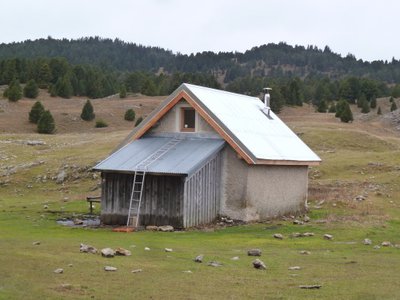
Pré Peyret - PNRV At the crossroads of several important trails, the Cabin de Pre Peyret is one of the most frequented of the massif. Located at the entrance of the high plateaus at 1600 m, this unguarded stone hut can accommodate 10 people for the night. It has a stove.The place exudes an old tradition of welcome because it is an old cabaret where those who were penniless went to drink at the Fountain of the Endettés, which bears his name well.
Forecast
Sensitive areas
Large plateaus at an average altitude of 1,600m, these landscapes are well-known to lovers of wide open spaces where humans have discreetly left their mark over the centuries. The fauna and flora also appreciate these places, where you can observe the two emblems of the Park: the wild tulip and the black grouse. Rock birds particularly appreciate the large cliffs that border these plateaus, and mountain orchids brighten the sparse mountain pine forest. Classified as a National Nature Reserve since 1985, this heart of nature benefits from strong protection. Human activities are regulated, and certain rules apply to everyone: dogs are prohibited, even on a leash; fires are also prohibited, as are motor vehicles, except for professionals (shepherds and breeders, forest managers, and rangers); bivouacking is possible, but tents must be taken down every day. Overflight is prohibited below 300m
- Impacted practices:
- , ,
- Sensitivity periods:
- JanFebMarAprMayJunJulAugSep
- Contact:
https://www.parc-du-vercors.fr/
Black grouse - winter
- Impacted practices:
- , , ,
- Sensitivity periods:
- JanFebMarAprDec
- Contact:
Recommandations

The route is straightforward when the weather is clear. But bad weather can make orientation tricky, and there is no mobile phone reception.
In summer, one of the main difficulties is managing your supply of water. For more information on the flow rate of the springs, please consult infosource website before you start your journey.
If you are not very experienced, don’t think twice about calling on the services of a trained, skilled mountain guide.
Information desks
Place Pietri, 26 420 La Chapelle-en-Vercors
Le Village, 38930 Chichilianne
More information

Report a problem or an error
If you have found an error on this page or if you have noticed any problems during your hike, please report them to us here: