The different faces of Mont Aiguille
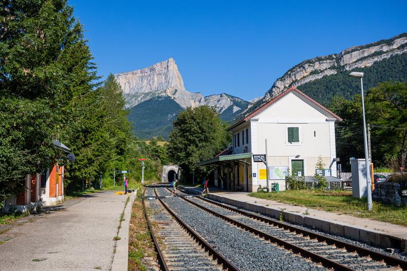
Clelles

The different faces of Mont Aiguille
4h
11,5km
+473m
-473m
Embed this item to access it offline
This hike has a forest, bucolic atmosphere with some unforgettable sites along the way: the Darne viaduct and the hamlet and chapel of Trézanne not to mention splendid viewpoints for contemplating Mont Aiguille.
5 points of interest
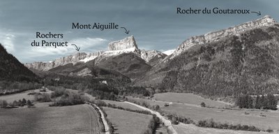
A. Poiraud The mountain with a nasty sting
The name «Mont Aiguille» appears quite late on geographical
maps, not before the 17th century. However, the mountain is not pointed like a needle, as suggested by its name.
It is possible that the local dialect term «aguïo» for a
pointed rock might have been confused with the Occitan term «eyguèyo» equivalent to «aiguière» in French, meaning a water vessel. Thus, Mont Aiguille would
most likely come from the Occitan name for this mountain (Peiro Eyguèyo), which refers to a «Mountain of Springs», because of the numerous springs at the foot of its northern face (Francès, 1997).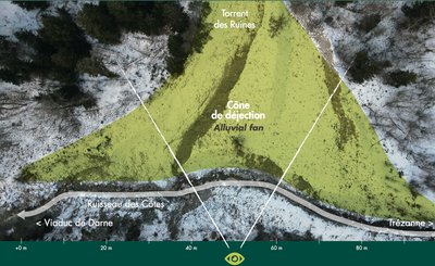
A. Poiraud Part of Mont Aiguille
The alluvial fan is the lower section of a mountain stream where sediment is deposited. The fan is clearly visible in front of you, and its sediment comes from the northern foot of Mont Aiguille. The Côtes stream from Trézanne struggles to make its way through all the tributaries of the Ruines stream.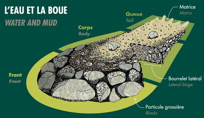
Torrent des Ruines
The toponym “les Ruines” is common in the Alps, often referring to unstable terrain that suffers heavy erosion and torrential flooding: lava, a mixture of water, earth and blocks of stone. The floods move at speed (at tens of km/h) in a very straight, steep channel, but behave like a drift that can transport blocks several cubic meters in size (the equivalent of a car or even a van) just like volcanic lava.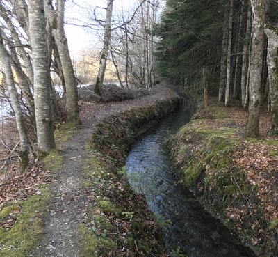
M. Rocheblave An irrigation canal
In 1821, a group of local farmers constructed a canal to irrigate parts of their land and gardens in Clelles. The canal was fitted with numerous sluice gates, but only members of the Syndicate were entitled to have access to the water supply.
At the beginning of the 20th century, Mr Corréard, a local miller, leased part of the rights to operate an electric power plant. In addition to running his mill, he became an electricity producer and supplied the commune of Clelles. In 1948, the power plant was connected to the national electricity grid!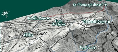
The Clelles canal
The piped water is a story of slope.
Controlling the slope allows to control the regularity of the water flow.
Elevation at start : 897 m
Elevation at arrival : 880 m
Lenght : 3 km
Description
- On leaving the train station, take the street on the left (north-west) to head towards the reservoir. Carry on towards Génie and Bois des Chaux.
- Continue until you get to Darne, where you will be at the foot of the Darne viaduct. Cross under the viaduct and climb up to the hamlet of Trézanne via Au Fontaniou.
- In Trézanne, walk to the chapel of the hamlet so you can enjoy a breathtaking view of Mont Aiguille. Now return on the D7C towards Ruthière via Les Ruines (crossing a stream by a ford), Aux Fontaines and Ruthière. A little further on, take the path on your left in the direction of La Scie/Clelles.
- At La Scie, carry on along the D7 in the direction of the train station. After you pass a huge rock, take the track on the left and follow the path along a canal and continue on the PR until you get to the D7.
- Cross the road, and walk along the path in front of you to get to Mailletère and the train station.
- Departure : Clelles
- Arrival : Clelles
- Towns crossed : Clelles, Saint-Martin-de-Clelles, and Chichilianne
Forecast
Altimetric profile
Sensitive areas
Along your trek, you will go through sensitive areas related to the presence of a specific species or environment. In these areas, an appropriate behaviour allows to contribute to their preservation. For detailed information, specific forms are accessible for each area.
Large plateaus at an average altitude of 1,600m, these landscapes are well-known to lovers of wide open spaces where humans have discreetly left their mark over the centuries. The fauna and flora also appreciate these places, where you can observe the two emblems of the Park: the wild tulip and the black grouse. Rock birds particularly appreciate the large cliffs that border these plateaus, and mountain orchids brighten the sparse mountain pine forest. Classified as a National Nature Reserve since 1985, this heart of nature benefits from strong protection. Human activities are regulated, and certain rules apply to everyone: dogs are prohibited, even on a leash; fires are also prohibited, as are motor vehicles, except for professionals (shepherds and breeders, forest managers, and rangers); bivouacking is possible, but tents must be taken down every day. Overflight is prohibited below 300m
- Impacted practices:
- , ,
- Sensitivity periods:
- JanFebMarAprMayJunJulAugSep
- Contact:
- https://www.parc-du-vercors.fr/
Recommandations
Use the purpose-built throughways to cross fences; shut gates and barriers behind you.
Keeping to the signposted paths means you'll respect private property.
Keeping to the signposted paths means you'll respect private property.
Information desks
Transport
To and from
By train : Clelles train station - Line Grenoble-Gap
The OùRA multimodal route planner provides information about all the connections between regional trains, urban transport and departmental bus lines: https://www.oura.com/
OR
By bus :
Line T95 from Grenoble or Clelles train station, and stop at Monestier de Clermont.
Then reach the car park by hitchhike or carpooling.
Access and parking
From Monestier-de-Clermont, take the departmental road D1075/ E712 to Clelles.
The train station is located in the West of Clelles, on the other side of the departmental road.
The train station is located in the West of Clelles, on the other side of the departmental road.
Parking :
the train station
More information
Report a problem or an error
If you have found an error on this page or if you have noticed any problems during your hike, please report them to us here: