Chemins de la Liberté – The Path to Freedom: Vassieux Necropolis
Vassieux-en-Vercors
Chemins de la Liberté – The Path to Freedom: Vassieux Necropolis
1h
2,4km
+33m
-31m
Embed this item to access it offline
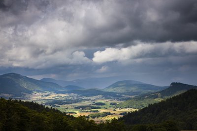
A commemorative route on the wide karst plateau of Vassieux punctuated by limestone pavements and sinkholes.
2 points of interest
Plateau de Vassieux - S.M Booth Plateau of Vassieux-en-Vercors
The plateau of Vassieux-en-Vercors is an open landscape characteristic of the karstic plateaus, the surface water is almost non-existent and the soils are not thick. However, dolines, which are depressions where the clay accumulates, thus allowing the cultivation of cereals, alongside these dolines, the stones are heaped up. There used to be many windmills to grind grain.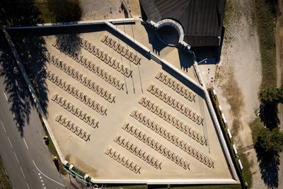
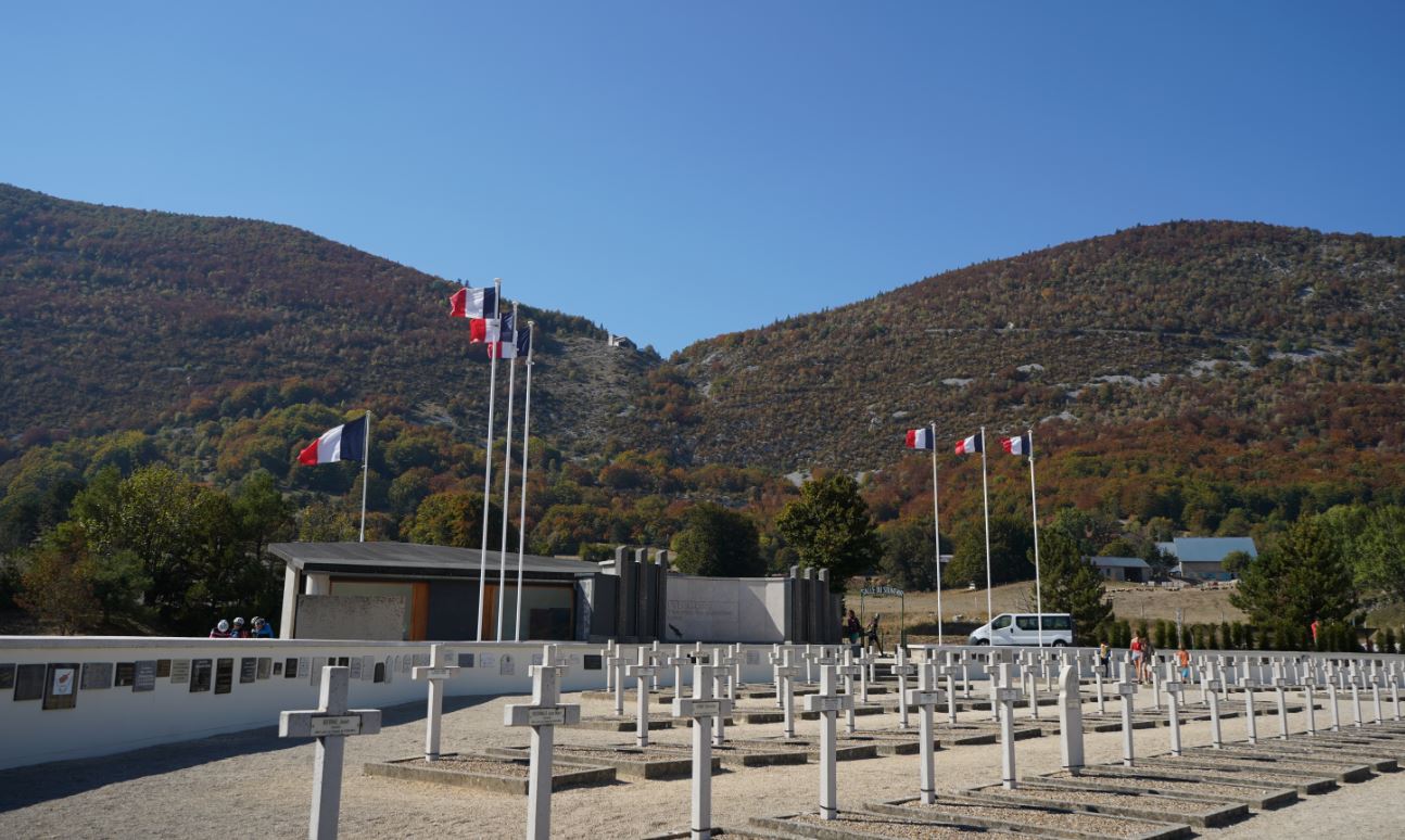
Nécropole - Focus outdoor Vassieux-en-Vercors Necropolis
After the village of Vassieux, you can discover the Necropolis, where all the civilian and military victims of the events in Vassieux lie buried. In addition to the people of the village, the graves show us that the Resistance in the Vercors was a huge civil and military movement that brought together men and women of many different nationalities. On the stone slabs can be read the names of Russian, Polish, Algerian, English and American soldiers and members of the Maquis. The shells of two of the gliders the German soldiers landed are on display beyond the graveyard. The Memorial to the Resistance, which is managed by the Vercors Park and the departmental Resistance Museum, help you learn more about the Vercors Maquis.
Description
- Set off from the Necropolis car park. Cross the D76 at the gate and follow the signposted path opposite towards La Grande Peyrouse.
- At the La Grande Peyrouse intersection, continue on towards Pourlette.
- In Pourlette, an interpretation panel explains the geological formation of the Vercors. Cross the D76 again and take the path opposite that goes across fields and leads to the site of an old water mill, which has been recently redeveloped. Once you are on the path, turn right towards the Necropolis. The trail will take you back to the starting point.
- Departure : the Necropolis of Vassieux-en-Vercors
- Arrival : the Necropolis of Vassieux-en-Vercors
- Towns crossed : Vassieux-en-Vercors
Forecast
Recommandations
Use the purpose-built throughways to cross fences; shut gates and barriers behind you.
Keeping to the signposted paths means you'll respect private property.
Keeping to the signposted paths means you'll respect private property.
Information desks
Place Pietri, 26 420 La Chapelle-en-Vercors
Transport
By train :
Grenoble, Valence or Die train stations
OùRA multimodal route planner : https://www.oura.com/
By bus :
From Valence :
From train and bus stations : Line D05 to Vassieux-en-Vercors
From Grenoble :
With regional coaches, line T64 by Engins or T65 by Saint-Nizier-du-Moucherotte and go to Villard)
- Then take the "on demand coaches" (except sunday and public holidays)
Booking mandatory, call to +334 8000 7000, at least 24h before you come.
By hitch hiking : You can get there / get back by hitching a lift with the Rezo Pouce network from Autrans-Méaudre, Lans-en-Vercors, Grenoble and Royans-Vercors (you can find all the stops in the Vercors on www.rezopouce.fr).
Carpooling :
Offer your services or book your carpooling on the regional Mov'Ici platform.
Access and parking
From Villard-de-Lans or Pont-en-Royans, take the direction to La Chapelle-en-Vercors, then follow Vassieux-en-Vercors on the road D178.
From Col de Rousset, take the road D518 and then the road D76 going to Vassieux-en-Vercors.
You can reach Resistance necropolis (Nécropole de la Résistance) in 2 min by car from the village center.
From Col de Rousset, take the road D518 and then the road D76 going to Vassieux-en-Vercors.
You can reach Resistance necropolis (Nécropole de la Résistance) in 2 min by car from the village center.
Parking :
Necropolis car park
Report a problem or an error
If you have found an error on this page or if you have noticed any problems during your hike, please report them to us here: