The Ecouges
Saint-Gervais

The Ecouges
4h
8km
+623m
-113m
Embed this item to access it offline
The sensitive nature area of Ecouges: a heritage to preserve.
The site of Ecouges extends between 880 m and 1636 m of altitude and is essentially mountainous.
With a surface area of 918 ha, it includes various ecological groupings induced by the type of soil and topography: a dry beech forest on lapiaz, wetlands on impermeable terrains, pastures, a spruce forest, a fir beech forest and A maple slope under a cliff.
The Ecouges site is representative, on a departmental scale, of the diversity of forest environments on the montane floor of the limestone prealpine massifs.
It offers favorable conditions for a particularly abundant fauna: 70 species of birds, 22 species of mammals, 10 species of reptiles and fish.
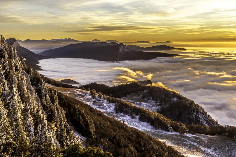
The path is more than eased towards the sheepfold of Fessole and reserves some impregnable views on the valley of the Isère.
The site of Ecouges extends between 880 m and 1636 m of altitude and is essentially mountainous.
With a surface area of 918 ha, it includes various ecological groupings induced by the type of soil and topography: a dry beech forest on lapiaz, wetlands on impermeable terrains, pastures, a spruce forest, a fir beech forest and A maple slope under a cliff.
The Ecouges site is representative, on a departmental scale, of the diversity of forest environments on the montane floor of the limestone prealpine massifs.
It offers favorable conditions for a particularly abundant fauna: 70 species of birds, 22 species of mammals, 10 species of reptiles and fish.
The path is more than eased towards the sheepfold of Fessole and reserves some impregnable views on the valley of the Isère.
Description
From Pont Chabert (882 m) follow the forest road towards the sheepfold of Fessole (8,1 Kms). The large trail along the stream allows easy access to the "Grandes Routes" 1 (995 m), then the passage du Versoud (oratory) and the old farm of Rivet 2 (1095 m). The Rivet viewpoint offers a magnificent view of the Isère valley. A sign indicates the sheepfold at 4.1 Kms. Take the track that runs east. At 1182 meters reach the Pré du Sabot 3. Leave on the right the Pas de Montbrand. At 1300 meters, leave the forest and continue north in the clearing. Quietly reach the sheepfold of Fessole 4 located under the Pas de la Pierre Taillée.
Return:
The return is the same as the itinerary of the go.
Return:
The return is the same as the itinerary of the go.
- Departure : Pont Chabert-Route des Ecouges
- Arrival : Pont Chabert-Route des Ecouges
- Towns crossed : Saint-Gervais and La Rivière
Forecast
Altimetric profile
Sensitive areas
Along your trek, you will go through sensitive areas related to the presence of a specific species or environment. In these areas, an appropriate behaviour allows to contribute to their preservation. For detailed information, specific forms are accessible for each area.
- Impacted practices:
- Contact:
- Alix Savine
Gestionnaire Espaces Naturels et Ruraux
Service Patrimoine Naturel
Direction de l’Aménagement
06 33 00 42 73
Recommandations
Path with no difficulty. In bad weather, orientation on the forest track is easy. It is necessary to enjoy a significant snowfall to be able to appreciate this itinerary. The starting point of the hike is at 882 meters above sea level.
More information on Nordic Walking
Nordic walking is a respectful and responsible practice. Before you jump into the field, do it.
More information on Nordic Walking
Nordic walking is a respectful and responsible practice. Before you jump into the field, do it.
Information desks
48 Grande Rue, 38680 Pont-en-Royans
Access and parking
From Grenoble, take the A49 towards Vinay (direction Valence). Take exit number 10 and join the village of St-Gervais. Continue on the D35 towards Col de Romeyère (Vercors). Reach Canyon des Ecouges and park in the parking at Pont Chabert.
Parking :
Parking of Pont Chabert
Accessibility
- Emergency number :
- 112
Report a problem or an error
If you have found an error on this page or if you have noticed any problems during your hike, please report them to us here: