The Moucherotte
Lans-en-Vercors


The Moucherotte
3h30
10,6km
+556m
-556m
Embed this item to access it offline
This route follows wide forest roads through very open landscapes. In the outward direction, you go around the plateau of Rows, while on the way back you cross it. At any time the scenery is breathtaking.
2 points of interest
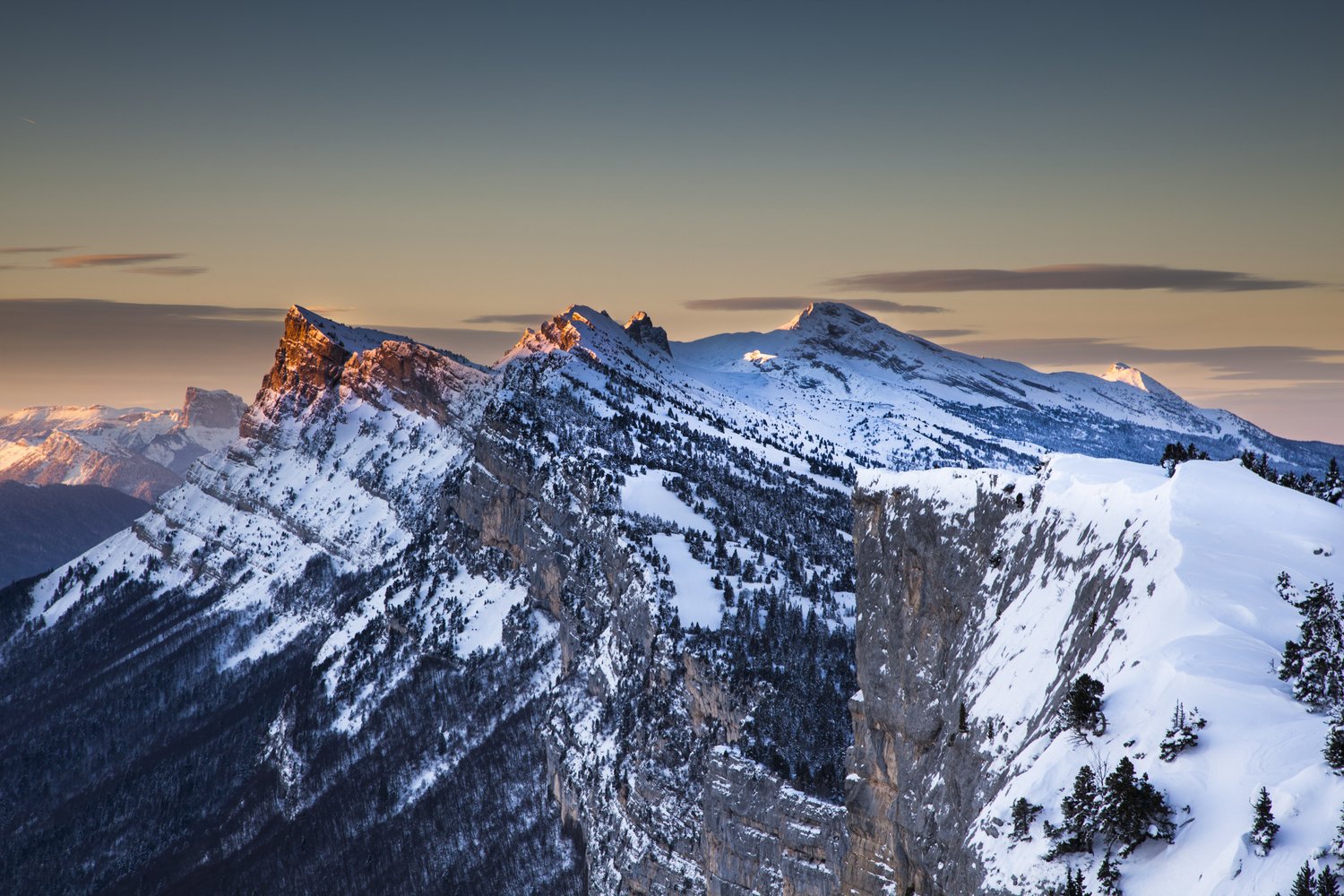
Les Trois Pucelles, Saint-Nizier et l'Isère vus du sommet - V. Giry Summit of Moucherotte
From its 1,901 meters, this summit offers a breathtaking view of the Alps and the valley of Grenoble. To better locate you in the surrounding massifs, an orientation table is at your disposal on the trail.You will also find on your way a radar of Météo-France. Installed in 2014, it can measure precipitation and wind within a radius of 50 kilometers.Until 2001, the Hotel Ermitage could also be seen standing on the Moucherotte, a luxury establishment that welcomed Brigitte Bardot, Dalida and Charles Aznavour. Abandoned since 1974 for lack of profitability, the hotel was connected to Saint-Nizier by a cable car. Only one pylon remains, which is now used by the village adventure trail.
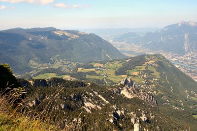
M. Rocheblave The plateau of Ramées
This vast, flowery alpine pasture is occupied in summer by village cows, an ancient breed of the Vercors, very adapted to its environment and restored to the taste by some local breeders. The plateau of Ramées, through its alternating wooded areas and alpine pastures, is an environment conducive to the black grouse. You can enter them cooing, but do not try to see them and especially stay on the paths, because this remarkable species is very sensitive to disturbance.
Description
1, prendre la direction du Moucherotte (direction nord).">From the "La Sierre" car park 1, take the Moucherotte direction (northbound). Reach three ski lifts. At the "Combe des Virets" ski lift, follow the GR (red and white paint on the trees). After 15 minutes, take the right track (GR). 2 (1500 mètres – itinéraire de la GTV été et du GR).">In 25 minutes you can reach "Les Virets" 2 (1500 meters - itinerary of the summer GTV and the GR). Leave the path to the right. 3 (1605 mètres – GR 91 et tour des 4 montagnes).">After 40 minutes you reach "Les Ramées" 3 (1605 meters - GR 91 and tour of the 4 mountains). 4 (1645 mètres).">Continue to the "Merdaret" 4 (1645 meters). Leave on the right the path that leads to the Ramées shelter (0,9 Km - 15 minutes). 5 (1700 mètres).">After an hour of skiing, you reach the Combe de Saint-Nizier 5 (1700 meters). The summit of the Moucherotte can be seen in the distance along the ridge. Leave the road on the right and continue towards the Moucherotte. Walk the ridge line for 20 minutes and then reach the top by a short but steep climb.
Go down following the climbing route. 5, prendre à gauche.">After 30 minutes of descent, back to the Combe de Saint-Nizier 5, turn left. After the sign, follow the southerly direction and stay in the unforested part. In 10 minutes you can reach the Ramées shelter (1620 meters). From the hut, continue in a southerly direction until you reach the climbing route. 1.">To join the parking of the Sierre 1.
Go down following the climbing route. 5, prendre à gauche.">After 30 minutes of descent, back to the Combe de Saint-Nizier 5, turn left. After the sign, follow the southerly direction and stay in the unforested part. In 10 minutes you can reach the Ramées shelter (1620 meters). From the hut, continue in a southerly direction until you reach the climbing route. 1.">To join the parking of the Sierre 1.
- Departure : Snow Stage of Lans-en-Vercors
- Arrival : Snow Stage of Lans-en-Vercors
- Towns crossed : Lans-en-Vercors, Saint-Nizier-du-Moucherotte, and Claix
Forecast
Altimetric profile
Sensitive areas
Along your trek, you will go through sensitive areas related to the presence of a specific species or environment. In these areas, an appropriate behaviour allows to contribute to their preservation. For detailed information, specific forms are accessible for each area.
- Impacted practices:
- , , ,
- Sensitivity periods:
- JanFebMarAprMayJunJulAugSepOctNovDec
- Contact:
Virginie Ruetsch - Chargée de mission ENS
virginie.ruetsch@pnr-vercors.fr
Black grouse - winter
- Impacted practices:
- , , ,
- Sensitivity periods:
- JanFebMarAprDec
- Contact:
- Fédération Départementale des Chasseurs d'Isère
Yannick Buzzarello : yannick.buzzarello@chasse38.com
Membre de l'Observatoire des Galliformes de montagne
Virginie Dos Santos : ogm.vds@gmail.com
Blandine Amblard : ogm.amblard@gmail.com
- Impacted practices:
- , ,
- Sensitivity periods:
- JanFebMarAprMayJunJulDec
- Contact:
Virginie Ruetsch
Chargée de mission ENS
0627604698
virginie.ruetsch@pnr-vercors.fr
Recommandations
There is no difficulty with this route. The skier will simply have to master the techniques of descent. Attention the summit of the Moucherotte is on edge of cliff
More information on Nordic Walking
Nordic walking is a respectful and responsible practice. Before you jump into the field, train yourself.
More information on Nordic Walking
Nordic walking is a respectful and responsible practice. Before you jump into the field, train yourself.
Information desks
246 avenue Léopold Fabre, 38250 Lans-en-Vercors
Transport
By train : Grenoble train station
By Bus:
- With Skiligne service : shuttle service from Grenoble to Lans en Vercors with two options : single return ticket (11,15€) or pack bus return ticket/full day ski pass (21.00€).
Departure at Grenoble train station to reach Lans en Vercors ski resort.
More informations and booking on the website : Transaltitude/Skiligne
- Free shuttle : From Grenoble take the regional buses line T64 ou T65 to Lans en Vercors. Then reach the ski resort with the free shuttle starting from the village centre.
Leaving from the village of Lans (8 stops in the village centre and the nearest hamlets), a free shuttle bus runs to the Lans mountains, linking the Lans alpine ski area and the Allières Nordic ski area.
The OùRA multimodal route planner provides information about all the connections between regional trains, urban transport and departmental bus lines: https://www.oura.com/
By hitch hiking :
Discover Rezo Pouce service with all the official stops on https://www.rezopouce.fr
Carpooling :
Offer your services or book your carpooling on the regional Mov'Ici platform.
Access and parking
From Grenoble, take the D106 road in the direction of Saint-Nizier-du-Moucherotte.
Continue on the D106 towards Lans-en-Vercors. Before the village, at the place "Les Bernards" turn right, and follow the road to the snow stage. Parking in the "La Sierre" car park 1,400 meters.
Continue on the D106 towards Lans-en-Vercors. Before the village, at the place "Les Bernards" turn right, and follow the road to the snow stage. Parking in the "La Sierre" car park 1,400 meters.
Parking :
Parking of the Sierre
Accessibility
- Emergency number :
- 112
More information
Report a problem or an error
If you have found an error on this page or if you have noticed any problems during your hike, please report them to us here: