GTV by Moutain bike - Saint-Romans (Le Marandan) / Rencurel (stage 4)
Saint-Romans
4. GTV by Moutain bike - Saint-Romans (Le Marandan) / Rencurel (stage 4)
4h
48,8km
+1955m
-1366m
Note: the times shown do not include rest stops and breaks. This time may vary according to each person's level of ability.
Embed this item to access it offline
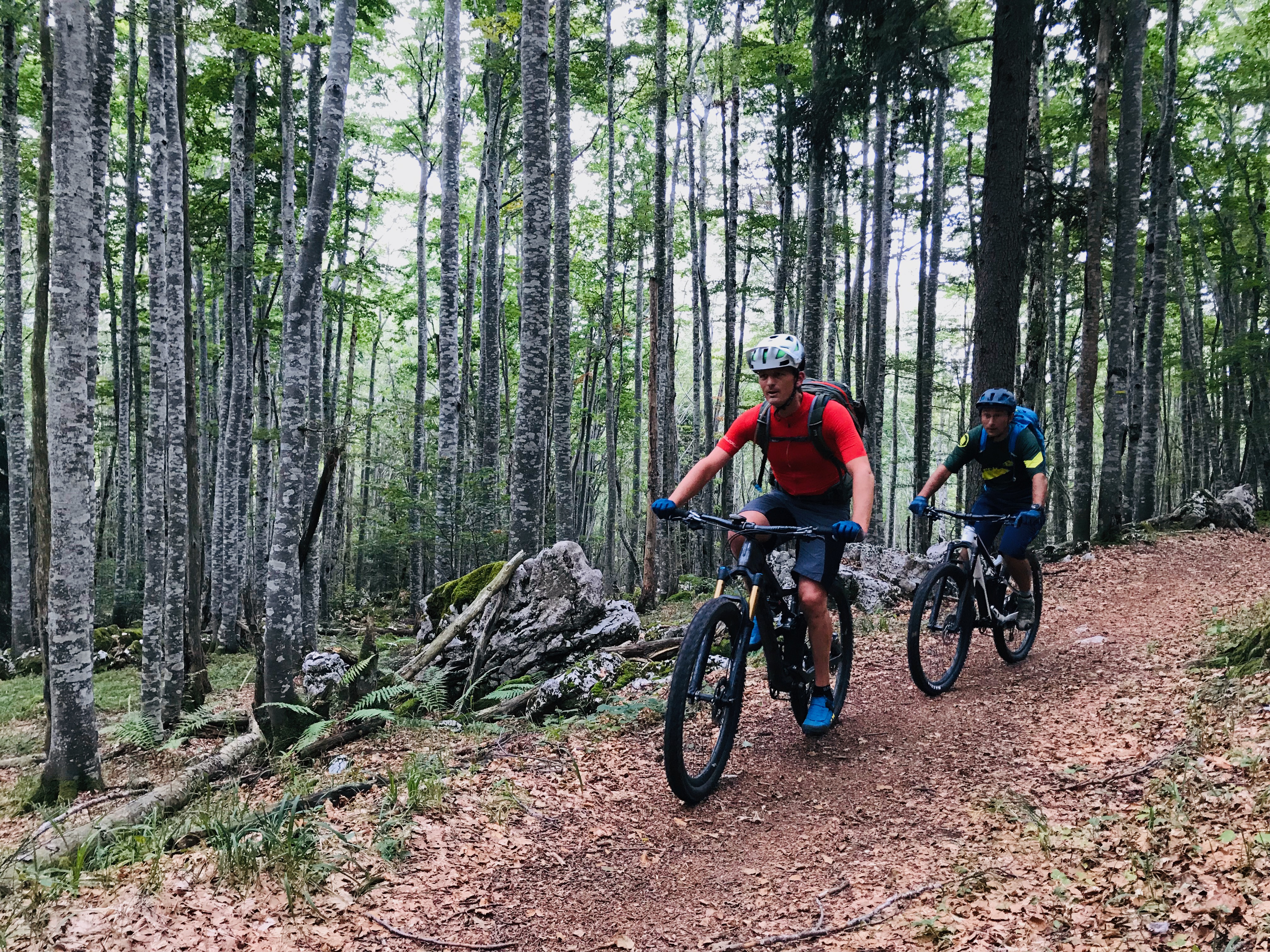
From walnut trees to beech forest, this is a wonderful segment that sets out from the plain of Isère before scaling the heights of the Vercors with its captivating panoramas! There’s a dramatic change in vegetation but the trails are great to ride along as you make your way to Rencurel.
3 points of interest
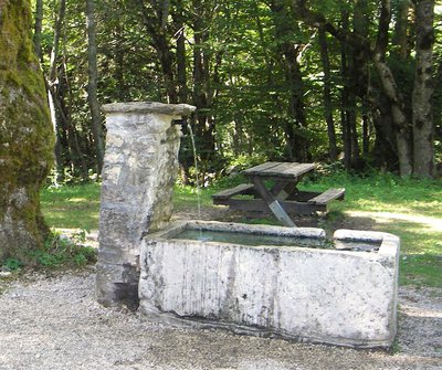
La fontaine de Pétouze - M. Rocheblave Fountain of Pétouze
Near the parking lot, a little further up the road you will find the Pétouze fountain and its picnic area. This fountain is one of the few permanent sources of the Coulmes massif, which has very few water points on the surface.Indeed, on a karst ground, water tends to infiltrate quickly and deep into the ground to reemerge further and lower. On the Coulmes massif, the rain and melting water emerge in the valleys of the Nan, the Isère and the Bourne.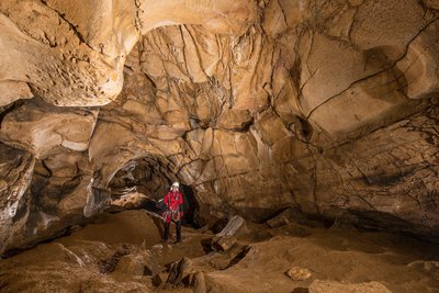
L'ntérieur de la grotte de Prélétang - S. Caillault Cave of Preletang
The cave of Preletang is the witness of human and animal occupations dating back several tens of thousands of years. Indeed, it has been the den of cave bears, species now disappeared, as evidenced by the rock made smooth by their repeated friction against the walls of the cave ("bear polis"). And the collapse of part of the porch sealed the traces of the Neanderthals who had stayed there 46,000 years ago.More than 300 flint tools were discovered on the site. They are made up of scrapers, spearheads, and waist chips. Most of the tools were not made locally but brought by the Neanderthals who were sheltering under the porch of the cave during hunting expeditions. The remains of wildlife brought to light consist of stag, deer, wild boar, marmot and ibex.Thus, thanks to this exceptional site, it is known that Neanderthals traveled the plateau of Vercors before the last glaciation. These men, our distant cousins, knew perfectly where to shelter, hunt and collect flint. It will be necessary to wait until the end of the last ice age (the Würm) so that the man, this time modern, ventures again on the massif.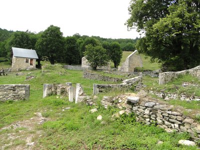
Les ruines du hameau de la Goulandière - OTSI Pont-en-Royans The Goulandière
The ruins of Goulandière tell the story of men who came to cultivate the land in this hamlet lost in the heart of the forest of Coulmes, without any water, as a challenge to nature. The houses are built on the rock, not to reduce the fields gained on the forest. The recent rehabilitation of the hamlet makes it possible to imagine this rude existence. Theme circuits invite you to discover the lifestyles of the Middle Ages.
Description
- After a brief refreshing break on the shores of Lake Marandan, it’s time to head off again on a beautiful stretch with quite a bit of climbing as you head up to the heights of the massif. After going through the village of Saint-Romans, the tour passes close to the couvent des Carmes in the municipality of Beauvoir-en-Royans, crossing fields and walnut groves along relatively smooth tracks to the village of Izeron.
- On leaving the village of Izeron, the serious stuff begins as you follow a small path and then a sometimes-steep climb that continues along a very scenic country road with exceptional views over the Isère valley.
- The itinerary now takes you to the hamlet of Montchardon, known across the world for its Tibetan temple, before continuing along a very pleasant, smooth track.
- You continue to the hamlet of Faz in the municipality of Presles. You’ve now reached the plateau of Coulmes, where a great path zigzags between the box trees.
- This is leading you to the village of Presles, famous for its cliffs and rock climbing.
- The stage is far from over, since you still have to climb to Col de Pra l'Étang.
- This is followed by a descent to the old inhabited hamlet of Goulandière, before heading in the direction of the hamlet of Rimets and on towards Rencurel along a trail through the heart of the magnificent beech forest of Coulmes!
- Departure : Saint-Romans (Le Marandan)
- Arrival : Rencurel
- Towns crossed : Saint-Romans, Beauvoir-en-Royans, Saint-Pierre-de-Chérennes, Izeron, Presles, and Rencurel
Forecast
Altimetric profile
Sensitive areas
Along your trek, you will go through sensitive areas related to the presence of a specific species or environment. In these areas, an appropriate behaviour allows to contribute to their preservation. For detailed information, specific forms are accessible for each area.
- Impacted practices:
- Sensitivity periods:
- AprMayJun
- Contact:
- http://www.rencurel-vercors.fr/183-vallee-fossile-des-rimets-espace-naturel-sensible-.htm
Recommandations
Use the installed passages to cross fences, close gates and barriers.
Stay on the marked trails and respect private property.
The trails can be slippery in rainy conditions!
Do not cross hay meadows or cultivated fields.
Collect your waste, think nature.
Stay on the marked trails and respect private property.
The trails can be slippery in rainy conditions!
Do not cross hay meadows or cultivated fields.
Collect your waste, think nature.
Information desks

48 Grande Rue, 38680 Pont-en-Royans
Transport
By train: Saint-Hilaire-du-Rozier SNCF station
By bus: From Grenoble, line T60, Grenoble>Pont-en-Royans stop Saint Romans
The OùRA multimodal route calculator gives you access to all the connections between regional trains, urban transport and departmental bus lines: https://www.oura.com/
By bus: From Grenoble, line T60, Grenoble>Pont-en-Royans stop Saint Romans
The OùRA multimodal route calculator gives you access to all the connections between regional trains, urban transport and departmental bus lines: https://www.oura.com/
Access and parking
From Pont-en-Royans, take the departmental road RD 1532 towards Saint-Just de Claix. Shortly after Saint-Just de Claix, take the D71 as far as the Marandan outdoor activities centre.
From Grenoble take the RD 1532, after crossing the village of Saint-Romans, at the roundabout before Saint Just de Claix take the D71 to the outdoor activities centre.
From Grenoble take the RD 1532, after crossing the village of Saint-Romans, at the roundabout before Saint Just de Claix take the D71 to the outdoor activities centre.
Parking :
In front of the Marandan outdoor activities centre
More information
Report a problem or an error
If you have found an error on this page or if you have noticed any problems during your hike, please report them to us here: