East-West crossing of the Vercors on the GR®93 - Stage 4
Vassieux-en-Vercors


4. East-West crossing of the Vercors on the GR®93 - Stage 4
5h30
15,5km
+917m
-685m
Embed this item to access it offline
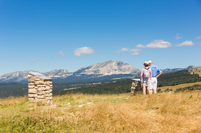
An itinerary blessed with myriad viewpoints!
6 points of interest
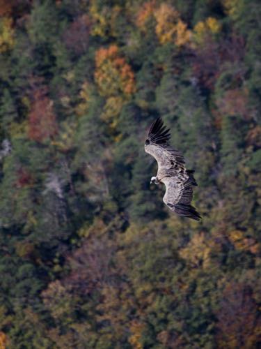
Vautour - m_rocheblave The Vulture Ball
At the beginning of the 2000s, the Regional Natural Park of Vercors participated in an operation to reintroduce vultures fawn on the scale of the Pre-Alps. These birds had disappeared from our mountains in the 19th century. A vast population now occupies a space that goes from the Spanish Pyrenees to the Vercors and that the birds run freely (the observation of the banded birds proves it to us). The Col de Rousset and the circus of Archiane are two sites of rest and nesting of these great gliders (almost 3m of wingspan). They use the ascending currents along the cliffs to transit from one to the other. A large shadow on the ground, raise your head, a vulture passes over you ...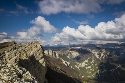
But de l'Aiglette - S.M Booth The But de l'Aiglette 1524m
The But de l'Aiglette with its 1524 m, is a promontory of the cliffs South of the Vercors. The 360 ° panorama is magnificent: from the Diois to the South to the plateau of Vercors in the North.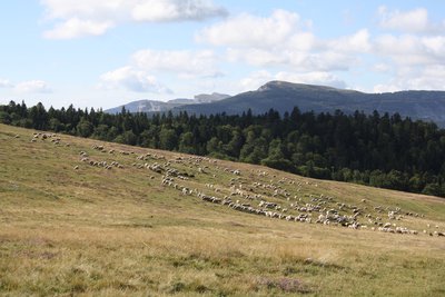
Alpage de Chironne - P.Mayade The Chironne mountain pasture
It is an enclave of the commune of Chamaloc located at the foot of the road of the pass of Rousset on the plateau of Vercors. Pastoral tradition of the south of France, the transhumance of the sheep is registered in the agricultural practices for more than 1000 years. Each commune of piedmont has always sought to have alpine pastures on the surrounding mountains. A pastoral grouping, allows several breeders of the villages below, associated with colleagues of Alpes de Haute Provence, to finance a shepherd and the equipment necessary to the sheep of a herd of sheep: access track, catchment of sources , Water reservoir and sheepfold. Attention, we are in a wolf zone. The herds are protected by Patou dogs. If you cross sheep, make a wide detour. Keep your dog on a leash!
Vtt sur le chemin de Chironne - PNRV Ancient Roman road
A superb mule track (ancient Roman road), carved in the middle of a cliff, allowed the convoys of mules and the flocks to climb from the Diois, to reach the Chironne meadow and then, via the eponymous pass, to Vercors. This development, which required many years of work and many years of work, shows the men's perseverance in providing access to the valuable resources of mountain pastures.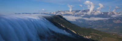
S.M Booth In balance between 2 climates
On the South Corniche of the Vercors, you progress on a line of climate change. In the slopes to your right, descending towards the valley of the Drôme, one finds holm oaks, one of the emblematic trees of the garrigue, vegetation of the Mediterranean climates. If you hike in July, you will probably notice purple squares among the fields below. These are the most northern lavender of France. The perspective opens up the valley of the Drôme. The big rock in front of you, the Glandasse, forms the southernmost point of the Vercors Hautes Plateaux Nature Reserve and marks the extreme advance of the Northern Alps. The massifs which close the horizon to the south make with the Baronnies on the left bank of the Drôme and Mediterranean climate obligatory, part of the Pre-Alps of the South.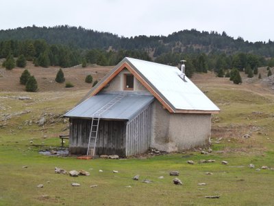
Pré Peyret - PNRV At the crossroads of several important trails, the Cabin de Pre Peyret is one of the most frequented of the massif. Located at the entrance of the high plateaus at 1600 m, this unguarded stone hut can accommodate 10 people for the night. It has a stove.The place exudes an old tradition of welcome because it is an old cabaret where those who were penniless went to drink at the Fountain of the Endettés, which bears his name well.
Description
- If you stopped off at Vassieux-en-Vercors, head towards Carrefour d'Espeline via the Regional GR® of the Drôme Vercors Tour and then the GR®93 to reach Col de Chironne (Chironne pass).
- If you are coming from Col de Vassieux, follow the Regional GR® of the Drôme Vercors Tour as far as Col de Chironne.
- Continue via the Col Naturel, La Combe (you can get to the Col de Rousset ski resort, approx. 500 m), Collet de Sapiau, But de Sapiau (gateway to the Hauts Plateaux du Vercors National Nature Reserve), Le Belvédère, Pas des Econdus and Pré-Peyret hut.
- Departure : Col de Vassieux (Vassieux pass)
- Arrival : Pré-Peyret
- Towns crossed : Vassieux-en-Vercors, Marignac-en-Diois, Chamaloc, Saint-Agnan-en-Vercors, Romeyer, and Gresse-en-Vercors
Forecast
Altimetric profile
Sensitive areas
Along your trek, you will go through sensitive areas related to the presence of a specific species or environment. In these areas, an appropriate behaviour allows to contribute to their preservation. For detailed information, specific forms are accessible for each area.
Large plateaus at an average altitude of 1,600m, these landscapes are well-known to lovers of wide open spaces where humans have discreetly left their mark over the centuries. The fauna and flora also appreciate these places, where you can observe the two emblems of the Park: the wild tulip and the black grouse. Rock birds particularly appreciate the large cliffs that border these plateaus, and mountain orchids brighten the sparse mountain pine forest. Classified as a National Nature Reserve since 1985, this heart of nature benefits from strong protection. Human activities are regulated, and certain rules apply to everyone: dogs are prohibited, even on a leash; fires are also prohibited, as are motor vehicles, except for professionals (shepherds and breeders, forest managers, and rangers); bivouacking is possible, but tents must be taken down every day. Overflight is prohibited below 300m
- Impacted practices:
- , ,
- Sensitivity periods:
- JanFebMarAprMayJunJulAugSep
- Contact:
- https://www.parc-du-vercors.fr/
Griffon vulture
- Impacted practices:
- , ,
- Sensitivity periods:
- JanFebMarAprMayJunJulAugDec
- Contact:
Black grouse - winter
- Impacted practices:
- , , ,
- Sensitivity periods:
- JanFebMarAprDec
- Contact:
Griffon vulture
- Impacted practices:
- , ,
- Sensitivity periods:
- JanFebMarAprMayJunJulAugDec
- Contact:
- nicolas.renous@pnr-vercors.fr
Recommandations
Use the installed passages to cross fences, close gates and barriers.
Stay on the marked trails and respect private property.
The trails can be slippery in rainy conditions!
Do not cross hay meadows or cultivated fields.
Stay alert in spring: snowfields can last late into the season! (Check with the tourist office before setting out).
Important: when the weather is hot in summer, make sure you take ample water with you as well as adequate sun protection, including sunscreen, a hat or other essentials.
Parts of the route are at high altitude and may be covered in snow in winter. These sections may be impassable depending on your mode of transport.
Herd protection dogs
In the mountain pastures, the guard dogs are there to protect the herds from predators.
When I hike, I adapt my behaviour by going around the herd and pausing so that the dog can identify me.
Click here to see the video : c'est quoi au juste un chien de protection ?
National nature reserve of Vercors Hauts plateaux
The national nature reserve of Vercors Hauts plateaux is an unrestricted natural area but subjected to regulations which must be known by all visitors. This reserve, created in 1985 by the French government, is the heart of the Vercors Park, with no permanent habitations or roads running through it. Unique in its size (17,000 hectares), the Hauts-Plateaux du Vercors reserve covers 8% of the Vercors Regional Nature Park. It is now the largest terrestrial reserve in mainland France.
It is open to all, but it's subject to a number of regulations that you will need to be aware of to prepare for your stay.
Information desks
Place Pietri, 26 420 La Chapelle-en-Vercors
Report a problem or an error
If you have found an error on this page or if you have noticed any problems during your hike, please report them to us here: